This page provides trail descriptions for trails in Purcell Wilderness Conservancy Park. For more information about this park, visit the main Purcell Wilderness Conservancy park page.
Check the trail conditions report before heading out.
Be prepared
- There are several rough horse trails on the east side of the park on the main Dewer, Dutch, Findley and Toby drainages.
- You can access the west side of the park on hiking trails. Day hikes are popular on the lower reaches of Hamill Creek to visit the old compressor site using the cable cars, and on Fry Creek to see the canyon.
- Rivers may be impassable during flood season, usually until the end of July. There are few bridges on the east side of the park. Bridges and three cable cars are in place on the lower end of Hamill Creek and Fry Creek.
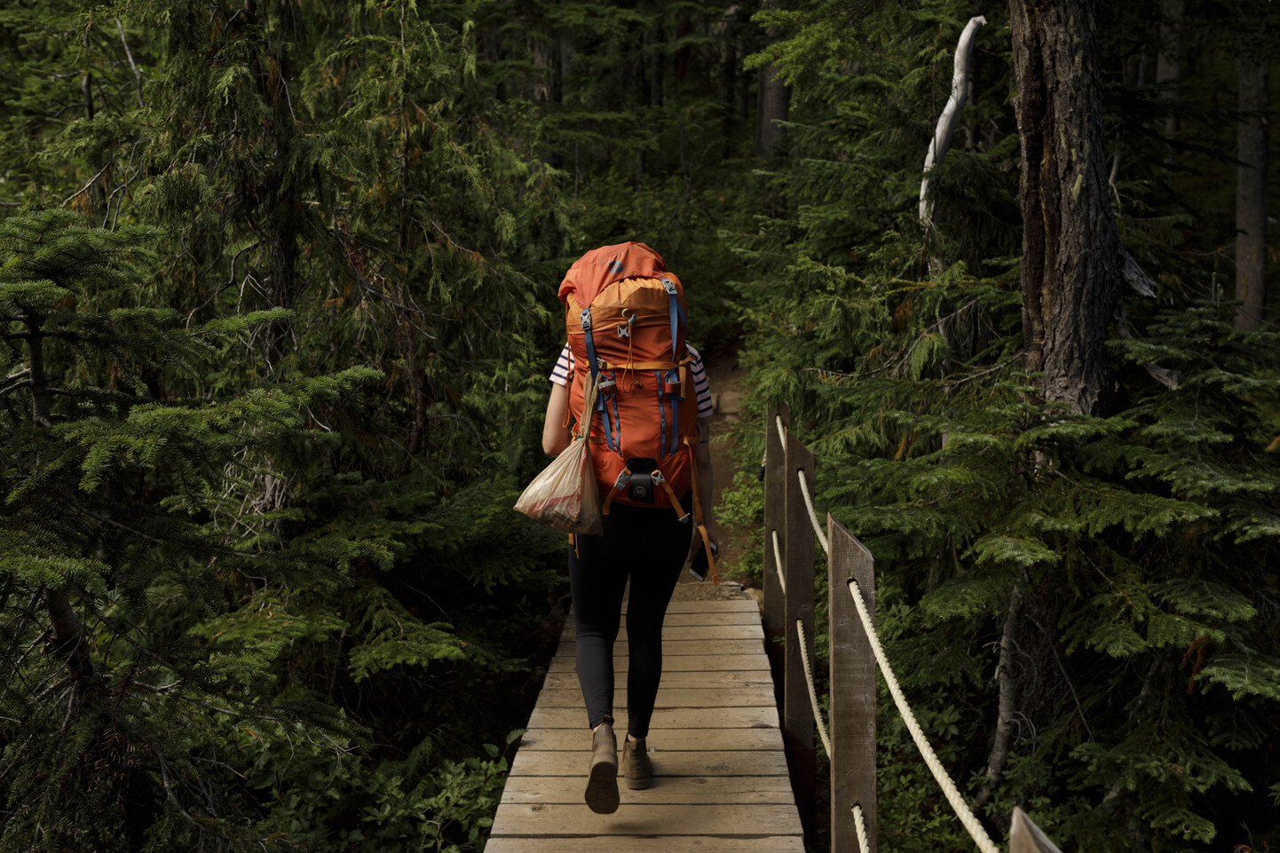
- Bring gloves to pull yourself across on the cable cars.
- Be prepared for a wilderness experience. You must be able to read maps, and capable of route finding. The park has no facilities or marked trails, and is not regularly maintained. Visitors should be self-sufficient and proficient in backcountry travel practices.
Learn more about backcountry travel in our backcountry guide.
Dewar Creek Hot Springs
Dewar Creek hot springs
One of the special features of the park is the Dewar Creek hot springs. Water flowing through fractures into the substrate is heated to temperatures above 100 C or boiling point. It rises to the surface carrying many minerals in solution especially calcium, magnesium and sulphur compounds. Hot water at the surface vents is above 80 C, too hot for bathing.
Visitors to the springs have created a variety of pools over the years using both natural and manmade materials. All except one small pool have been removed. BC Parks will continue to remove any new construction and request your cooperation. The intrinsic value of the springs for wildlife use far outweighs modification of the springs for recreational bathing. Far better, more accessible opportunities for hot spring soaking exist at other locations in the Kootenay’s.
The minerals brought to the surface by the hot mineral springs form critical licks for five species of ungulates: elk, goat, white tail deer, mule deer, and moose providing them with high concentrations of minerals and nutrients during May through July, the birthing seasons. Unfortunately increased human visitation to the springs has displaced many of these animals and as a result wildlife populations in the upper Dewar have decreased.
Plants and wildlife
A number of rare vascular plants grow in the side hill bog immediately above the springs: Western St. John’s-wort, a yellowish orange flowered herb, Slender muhlenbergia, a small grass that occurs in dense mats close to the hot springs vents and Hot–springs Panicum another grass unique to hot springs ecosystems.
A red-listed damselfly Argia vivida commonly known as the “Vivid Dancer” has been identified at Dewar hot springs. Blue in colour it is sometimes seen clinging to the rubble and boulders near the hot-springs.
The Engelmann spruce-subalpine fir (ESSF) zone around the springs is dominated by Engelmann Spruce and sub-alpine fir. False azlea, white-flowed rhododendron and huckleberry are common.
Dewar hot springs and adjacent Bugle Basin area are an intricate and interdependent ecosystem. Just as ungulates depend on the hot spring licks for nutrients predators such as grizzly bear, wolves and wolverine depend on productive ungulate populations.
Trail details
This fragile and diverse area can be visited using an old outfitting trail. Drive west on the St. Mary’s forest service road 47 kilometres to the junction of the West Fork St. Mary’s road and the Dewar Creek road. Bear right and follow the Dewar Creek road to the end at the 27 km (the last 4 km is a very rough road and high clearance vehicles are recommended).
There is a trail registry located at the beginning of the trail.
After crossing Wesley Creek continue for about 1.5 hours till you drop down by the creek. If on horse the trail will soon cross the creek. If on foot scramble up onto the east bank and continue along a rough hiking trail that will rejoin the old outfitting trail, continue to the springs. About 3-4 hours total time.
At the springs the trail contours above the springs area and continues another .5 km to Bugle Basin, a huge slide area, where hiker camping is allowed.
There is an established horse camping area across the creek to the west, follow the trail that crosses the Dewar Creek immediately after emerging from the forest. Follow up the left side of Bugle Basin about .5 km then follow the trail back into the hidden meadow where an established horse camp is located. Please do not horse camp on the east side of Bugle Basin.
Past visitors have trampled the side hill area above the springs and destroyed rare habitat. In an effort to allow these areas to regenerate do not camp above the springs or trample the bog area. To traverse the hot springs use the horse trail above the bogs or the rocks along the creek.
The Earl Grey Pass Trail
The Earl Grey Pass Trail extends approximately 63 kilometres from Argenta at the north end of Kootenay Lake in the West Kootenay, up Hamill Creek, over the Purcell crest, and down Toby Creek toward Invermere in the East Kootenay. Conditions vary on this rigorous wilderness trail, and it should not be attempted except by experienced and well-equipped hikers. Extreme care must be taken whenever a creek is crossed, whether by bridge, by cable-car, or by fording. An average hiking-time for the trail is five days, but all suggested times are approximate, depending upon weather and individual hikers.
Argenta to Earl Grey Pass
Length: Approximately 45 kilometres. (2-3 days) Elevation gain from Argenta to Earl Grey Pass 1,341 metres. Maximum elevation 2,256 metres. Suggested hiking time; three days.
Argenta to compressor site
The Hamill Creek section of the Earl Grey Pass Trail starts near the old mining community of Argenta on the east side of Kootenay Lake. Argenta is accessible by secondary road from Highway 31 north of Lardeau. Follow the main road through the community for 4.25 kilometres beyond the Argenta Post Office. The trail begins as a rough logging track branching left from a sharp right bend on the main road. After about 1 kilometre, the track ends in a small clearing, from the lower right-hand end of which the hiking trail commences a steady but steep descent to an old bridge crossing Clint Creek. The trail then leads to Hamill Creek valley along the bed of a 1904 wagon road which includes some of its original bridging and corduroy sections.
First cable car crossing
The trail crosses Hamill Creek for the first time on a cable car installed prior to 1929 at the site of an old bridge. BC Parks has recently replaced all cable cars. Ensure that you bring gloves for pulling the car along the cable. It is then a short hike to the compressor site. At the compressor site is an example of the mining activity that took place in the area during the early 20th century; of interest is a 10-drill Allis-Chalmers compressor, driven by a pelton wheel which originally had a 35-metre head of water obtained from a small wing dam 750 metres up Hamill Creek. High-pressure air was pumped 1,200 metres up to the Argenta lead-silver mine on Lavina Ridge above Hamill Creek. In 1906, the year after the compressor was installed, the mine closed as ore ran out and eventually the incredible road built through the lower canyon became impassable to wagons. Hikers may wish to view the mine workings, rudimentary trails lead to them from the compressor site, however visitors are cautioned to stay out of the unstable mine tunnels and shafts.
Second cable car crossing: near the compressor site
From the compressor site, a short walk leads to McLaughlin Cabin, built by miners in 1906, and to a cable car, the second crossing over Hamill Creek. For about 2.5 km beyond the second crossing, the trail leads through an area of old forest fire burns where it is interesting to observe the succession forest of young alder, hemlock and Douglas-fir reclaiming the land. The valley floor is a climax forest of western hemlock and cedar undisturbed by any trace of roads, logging or mining. Fires have not reached the riparian zones for centuries and some of the giant trees are close to a thousand years old.
Third cable car crossing
About 8 km after entering the mature forest the trail arrives at the third cable car crossing where the trail crosses to the north side of the creek.
Fourth cable car crossing
It is about five km to the next crossing.
Fifth cable car crossing
The vegetation of the valley floor now reflects the transition from the hemlock, cedar, Devil’s Club, and ferns of the Western Hemlock Biogeoclimatic Zone into a subzone of the more open canopied Engelmann Spruce and Subalpine Fir Biogeoclimatic Zone in which white rhododendron and black mountain huckleberry compose the major ground cover.
Approximately 5 km above the fifth cable car crossing you cross Rock Creek, a small tributary of Hamill flowing down from a bowl below Cauldron Mountain to the north.
From Rock Creek it is about 3 kilometres to the bottom of the meadows, an area of spruce bog and sedge meadow. From Moose meadows campground, a newer section of trail aproximately 5 km long has been constucted on the North side of Hamill Creek that elimminates two dangerous log crossings over Hamill Creek. The trail then rejoins the old trail just before the North forks campground. Just past the North Fork of Hamill Creek, the trail climbs steeply for about 800 metres on a good grade.
Fry Creek Trail
History
As many other areas, the Fry Creek Trail had its early beginnings in mining. A placer claim was established on Fry Creek in 1893, but the area remained inactive until the 1920’s when a group of prospectors established the Pegleg Mine near the Confluence of Fry and Carney Creeks. They had discovered gold near the mouth of Fry Creek, and speculated that they would find the source here. To move equipment and supplies to the site, a pack horse trail was built from Johnson’s Landing to the mine site. Carving a trail out of the steep canyon required extensive drilling and blasting, and one of the workers fell to his death while constructing it. The prospectors eventually lost interest after years of effort produced only marginal returns.
In 1935, another prospector bought out the claim, and he and his family maintained the Trail for some time. But he was also unable to make it profitable, and finally gave up on the mine after yielding only 31 grams of gold. The Fry and Carney Creeks also attracted the Bacchus’s brothers who trapped throughout these drainages. The Bacchus’s were also responsible for stringing telegraph wire and introduced early communication to Birchdale, some of which can still be seen on the trail between this Community and Johnson’s Landing.
The Fry Creek Canyon Recreation Area was originally established to protect the Trail and the unique geological features of the Canyon. In 1995 the boundaries of the neighbouring Purcell Wilderness Conservancy were expanded to include the Fry Creek Canyon Recreation Area, and the resulting 202,709ha were designated as a Class “A” Provincial Park. The Purcell Wilderness Conservancy, along with the adjacent St. Mary’s Alpine Park (9,164ha) protects a significant, wild and beautiful region within the Purcell Mountains.
The Fry Creek Trail
The Fry Creek Canyon Trail is no longer a designated route and not maintained. The Fry Creek and Carney Creek drainages are considered wilderness areas. Use at your own risk and route-finding skills are required.
The Birchdale Trail continues for 2km beyond the Fry Creek bridge. This trail ends at private property and there is no designated trail access to the community of Birchdale at this time.
Toby Creek to Earl Grey Pass
Length: Approximately 16 kilometres. Elevation gain from Toby Creek to Earl Grey Pass: 1,070 metres.
Maximum elevation: 2,256 metres. Suggested hiking time, (2-3 days)
Invermere to Toby Creek and Earl Grey Pass trailhead – Approximately 32 km (20 miles) by road.
From Invermere follow the road that takes you to Panorama ski resort, at the ski area turn off (apx. Km 15 ) continue straight and stay on the Toby Creek FSR. You will pass Delphine Creek FSR and further up you will cross Jumbo Creek bridge. Just past the bridge the Road forks right to go to Jumbo pass or left to go to the Earl Grey Pass. Stay left and you will immediately be at the parking area for Earl Grey Pass Trail. This is the best place to park, (it is possible to drive further in a high clearance vehicle, but this road is unmaintained and not recommended). At the trailhead follow the old road along Toby creek past the old horse coral and follow the sign pointing you to the right at the next fork, continue on this old road/trail until you reach the Park Boundary.
Use extreme caution at all times while travelling the Toby Creek road. Logging trucks use the road extensively during working hours.
Boundary to Pharaoh Creek
Shortly after the Boundary the trail crosses three open slide meadows divided by strips of pine forest. At the second of these meadows is the cabin built for then Governor General Earl Grey in 1909. Pharaoh Creek is reached after crossing the third meadow.
Pharaoh Creek to MacKay’s Slide
The trail follows along or above the creek. At MacKay Falls the trail climbs through an old forest. You will come to a drift-fence. Beyond the drift fence, about five minutes along, the trail will split. The lower trail goes down to the creek and the upper trail climbs onto a large slide path, Mckay Slide, then goes up the slide and across it. Where the trail starts to drop near the west side of the slide is the elevation at which you should enter the forest. The trail will drop down about 25 vertical metres and then climb up through brush into the forest where a good trail will continue. Do not go down to the creek unless you want to camp.
Toby Falls Camp
The trail enters the forest on the west side of the McKay Slide, the trail maintains its elevation, following the contour around Redtop and Bannock Basin to a point above Toby Falls. Just above Toby Falls below the trail is a camp next to the creek.
Toby Falls Camp to Earl Grey Pass
Above Toby Falls the trail climbs, gradually, passing the outwash plain of Toby Glacier on the left. The trail is reasonably graded with a few steep switchbacks near the end. About ten minutes before you reach the pass there are a couple of small creeks crossing the trail. This is the last source of water until you are over the pass and down into the forest on the Hamill Creek side.